
Abhinav
Writer
Updated On - Jun 04, 2026
15 min
Published On - May 21, 2026
Adi Kailash Yatra, Pithoragarh: Everything You Need to Know Before You Go
Adi Kailash Yatra in Pithoragarh is a sacred journey known as Chhota Kailash. This guide covers route, permits, cost, and the best time to visit. Plan your spiritual trip with complete travel tips and essential details.
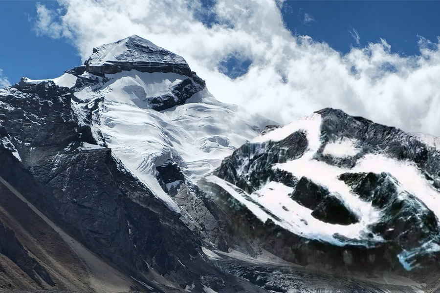
Tucked into the Pithoragarh district of Uttarakhand's Kumaon Himalayas, close enough to the Indo-Tibetan border that the mountain faces northwest toward Mount Kailash in Tibet, Adi Kailash is one of those destinations that rewards the traveller who has done a little reading before arriving — and leaves the one who hasn't feeling like they've only seen half the picture. Also known as Chhota Kailash, Baba Kailash and Jonglingkong Peak, the mountain rises to 5,945 metres and is the second most sacred of the Panch Kailash — the five earthly abodes of Lord Shiva scattered across the Himalayas — sitting above the Kuthi Valley and the last permanent Indian settlement before Tibet.
There's plenty here for the spiritually inclined, the adventure traveller and the culture enthusiast alike, and you'll be pleasantly surprised by how accessible the circuit has become in recent years. Until 2019, the Adi Kailash Yatra required a trek of roughly 200 kilometres — which made it the preserve of the committed and the physically fit. Since the Border Roads Organisation completed the Dharchula–Lipulekh Pass Highway in 2020, however, the entire circuit is largely motorable, with just a two-to-three kilometre walk at Jolingkong remaining for most pilgrims. The yatra now covers 18 distinct sightseeing points across the Kumaon foothills and the high-altitude border terrain, and it can be completed in eight days from Kathgodam, which is the standard starting point for most pilgrims coming from Delhi and the northern plains.
And to add to that, the 2026 season opens on 8 May, which means if you've been thinking about it, now is the time to start planning. Here's everything you need to know.
What Makes Adi Kailash Different From Other Himalayan Pilgrimages
Of the Panch Kailash — the five peaks considered to be the earthly residences of Lord Shiva — Adi Kailash is the only one in Uttarakhand, and the one that most closely mirrors the appearance and spiritual energy of the original Mount Kailash in Tibet. The resemblance is not just mythological; the snow formation, the sacred lake at its base and even the shape of the surrounding peaks echo the Tibetan Kailash in ways that pilgrims have described for centuries. Following the Chinese occupation of Tibet and the long closure of the Kailash Mansarovar route to Indian pilgrims, Adi Kailash naturally became the closest available alternative — hence the name Chhota Kailash, or Little Kailash.
According to the Puranas, Lord Shiva and Parvati halted at Jolingkong on their way from Kailash Mansarovar to the Triyuginarayan temple in Uttarakhand for their divine marriage. The Parvati Sarovar — the glacial lake at the base of the peak — is the spot where Parvati is believed to have bathed before that marriage, and the ancient Shiva Parvati temple on its shore marks the site of their temporary residence. The valley itself, the Kuthi Yankti, takes its name from Kunti, the mother of the Pandavas, who is said to have lived here during the years of exile. Kuti village at the head of the valley carries that name to this day, and the surrounding mountains — Brahma Parvat, Pandav Parvat, Parvati Mukut — make the mythological landscape feel unusually literal and present.
And then there's Om Parvat, which is something else entirely. At 5,590 metres, at the precise trijunction of India, Nepal and Tibet, snow settles on Om Parvat's dark metamorphic rock face in a pattern that reproduces the Sanskrit symbol ॐ with an exactness that has to be seen to be believed. It is the only mountain in the world where this formation occurs, and it forms every year, without any human involvement. You can view it from Nabhidhang at 3,987 metres — the last halt before Lipulekh Pass on the Indo-Tibetan border — and it is, by any standard, one of the most extraordinary things you will see in the Indian Himalayas.
The Key Locations and What to Expect at Each
The circuit covers a tremendous range of altitude — from Dharchula at 910 metres all the way up to Gauri Kund at approximately 5,000 metres — and each major stop has its own character. Gunji at 3,200 metres is the acclimatisation base and practical hub for the yatra, with guesthouses, homestays and the last reliable BSNL mobile signal before the upper reaches. Jolingkong at 4,378 metres is the highest campsite and the departure point for the 2–3 km walk to Parvati Sarovar and Gauri Kund. The table below maps everything out so you can get a clear sense of the elevation gain and what you're signing up for.
| Location / Site | Altitude | Altitude (ft) | Significance |
|---|---|---|---|
|
Pithoragarh — district headquarters |
1,627 m |
5,338 ft |
Last major town before the yatra begins; base for permits and supplies |
|
Dharchula — gateway and ILP base |
910 m |
2,985 ft |
Indo-Nepal border town on the Kali River; all permits issued here |
|
Tawaghat |
1,000 m |
3,281 ft |
Kali and Dhauliganga rivers meet here; border zone begins |
|
Gunji — acclimatisation halt |
3,200 m |
10,499 ft |
Last proper settlement; BSNL connectivity; acclimatisation day recommended |
|
Nabhidhang — Om Parvat viewpoint |
3,987 m |
13,081 ft |
Only accessible viewpoint in India for the natural ॐ on Om Parvat |
|
Jolingkong — Adi Kailash base camp |
4,378 m |
14,363 ft |
Highest campsite on the circuit; departure point for Parvati Sarovar trek |
|
Parvati Sarovar & Shiv Parvati Temple |
4,501 m |
14,767 ft |
Sacred glacial lake; temple on the shore; reflects Adi Kailash at sunrise |
|
Gauri Kund |
5,000 m |
16,404 ft |
Highest water body on circuit; bathing not permitted; closest Adi Kailash view |
|
Adi Kailash (Jonglingkong Peak) |
5,945 m |
19,505 ft |
2nd most sacred of the Panch Kailash; abode of Shiva and Parvati |
|
Om Parvat |
5,590 m |
18,340 ft |
Only mountain in the world with a natural ॐ snow formation |
|
Lipulekh Pass — Indo-Tibetan border |
5,334 m |
17,500 ft |
Historic trade route; on clear days, Mount Kailash is visible from here |
|
Kuti Village — last village of India |
3,700 m |
12,139 ft |
Named after Kunti (mother of the Pandavas); Byans community; 5 families year-round |
Table 1 — Key Locations: Altitude, Distance and Significance
The Route: How the Eight Days Actually Unfold

The standard Adi Kailash Yatra circuit runs eight days and seven nights from Kathgodam, covering both Adi Kailash and Om Parvat. What's lovely about the first two days is that the approach through lower Kumaon — with stops at Kainchi Dham, Jageshwar Dham and Chitai Golu Devta Temple — sets a spiritual tone before you've reached anywhere near the high Himalayas. Many travellers treat Days 1 and 2 as mere transit but that's a mistake, because the temple complex at Jageshwar alone — 125 ancient Shiva temples in a deodar forest, going back to the 7th century — is worth a visit in its own right.
Days 3 through 6 are the core of the yatra: Dharchula to Gunji, the Adi Kailash excursion to Jolingkong and back, and the Om Parvat darshan at Nabhidhang. The drive from Gunji to Jolingkong and back is 86 kilometres round trip and takes nine to ten hours including time at the sightseeing points, so an early start — around 6:30 AM from Gunji — is essential. Days 7 and 8 are the return, with an optional overnight at Chaukori, which offers some of the finest views of the Panchachuli peaks in the whole of Kumaon, if you want to ease out of the yatra slowly rather than rush back to the plains.
| Day | Route | Distance | Drive Time | Key Stops |
|---|---|---|---|---|
|
Day 1 |
Kathgodam → Pithoragarh |
~195 km |
6–7 hrs |
Bhimtal, Kainchi Dham, Chitai Golu Devta Temple, Jageshwar Dham, Almora — a temple-hopping day before the real yatra begins |
|
Day 2 |
Pithoragarh → Dharchula |
~96 km |
3–3.5 hrs |
Kali River valley drive; first views of the Nepal hills across the water; ILP and medical formalities at Dharchula |
|
Day 3 |
Dharchula → Gunji |
~80 km |
3–4 hrs |
Tawaghat, Malpa memorial, Budhi, Chialekh Valley; first snow peaks appear on the horizon |
|
Day 4 |
Gunji → Jolingkong → return to Gunji/Budhi |
86 km (r/t) |
9–10 hrs |
Nabi village, Kuti village, Brahma Parvat, Pandav Parvat darshan, Jolingkong base camp, Parvati Sarovar, Gauri Kund — the heart of the yatra |
|
Day 5 |
Gunji → Nabhidhang (Om Parvat) → Gunji |
~44 km (r/t) |
4–5 hrs |
Kalapani, Kali Mandir, Sheshnag Parvat, Ved Vyas Gufa, Om Parvat darshan at Nabhidhang |
|
Day 6 |
Gunji → Dharchula |
~80 km |
3–4 hrs |
Return via the same valley route; overnight in Dharchula |
|
Day 7 |
Dharchula → Chaukori /Didihat (optional) |
~96–130 km |
3.5–5 hrs |
Optional overnight at Chaukori for Panchachuli peak views; or drive through to Pithoragarh |
|
Day 8 |
Chaukori / Pithoragarh → Kathgodam |
~195–230 km |
6–8 hrs |
Return through Kumaon; Bhimtal, Bhowali on the way down |
Table 2 — Day-by-Day Itinerary: Standard 8-Day Road Circuit
A buffer day — ideally two — is something every experienced Himalayan traveller will tell you to build in, and they're right. Mountain weather is unpredictable, Om Parvat darshan can be obscured by a single cloud bank for an entire day, and the road between Dharchula and Gunji has sections that are vulnerable to landslides in the pre- and post-monsoon periods. The best packages include buffer-day accommodation at no extra charge; make sure yours does too before you book.
Getting There: All Your Options from Delhi
Kathgodam is the most common starting point — it's well connected to Delhi on overnight trains including the Ramnagar Express, and from Kathgodam the road journey to Dharchula, the gateway town, takes the better part of two days via Pithoragarh. If you want to save time, Pantnagar Airport has flights from Delhi on IndiGo, Air India and SpiceJet, and from there Dharchula is eight to nine hours by road. The most economical single option is the UTC direct bus from Delhi's Anand Vihar ISBT to Dharchula — it runs daily at around 4:30–5:30 PM and arrives in 21–24 hours at a cost of roughly ₹1,100. And for senior pilgrims or those with limited time, a helicopter from the Pithoragarh helipad to Gunji cuts the two-day road journey to 35–40 minutes, which makes the yatra genuinely accessible even for those who would not previously have considered it.
| Mode | Route | Time to Dharchula | Approx Cost | Best For |
|---|---|---|---|---|
|
Train + Road |
Delhi → Kathgodam (overnight train) → Pithoragarh → Dharchula |
Train 6–8 hrs + Road 2 days |
₹600–1,200 train + ₹1,500–2,500 road |
Most popular; groups; those on packages picking up at Kathgodam |
|
Direct Bus |
Delhi Anand Vihar ISBT → Dharchula (UTC overnight bus, departs 4:30–5:30 PM daily) |
21–24 hours direct |
₹1,070–₹1,130 |
Most economical single option; great for budget travellers |
|
Private Car |
Delhi → Moradabad → Haldwani → Pithoragarh → Dharchula (~550 |
14–16 hrs (1 long day) |
₹8,000–₹15,000 one-way cab |
Families; those with flexible itinerary and preferred stops |
|
Flight + Road |
Delhi → Pantnagar Airport (1 hr) → Pithoragarh → Dharchula |
Flight 1 hr + Road 8–9 hrs |
₹3,000–8,000 flight + road |
Good time-saver for those flying from outside Delhi |
|
Helicopter |
Pithoragarh helipad → Gunji (35–40 mins) |
Under 1 hour to Gunji |
₹12,000–₹20,000+ per person one way |
Senior pilgrims; limited mobility; quick 2–3 day darshan yatra |
Table 3 — How to Reach Dharchula: All Routes and Costs Compared
Permits and Registration: What You Need
Unlike most Himalayan destinations, you can't simply buy a ticket and head to Adi Kailash. The circuit passes through a restricted border zone under Indian law — given the proximity to both the Indo-Tibetan and Indo-Nepali borders — and every pilgrim must obtain an Inner Line Permit from the SDM office in Dharchula before entering the zone beyond Tawaghat. If you're travelling with a registered tour operator, they'll handle the entire permit process as part of your package. If you're self-organising, you can apply online through the Pithoragarh District ILP portal or walk into the SDM office in Dharchula; final verification happens at checkposts along the route regardless. A medical fitness certificate is also mandatory — doctors in Dharchula issue these on-the-spot if you haven't brought one from home.
| Permit / Document | Details | Where to Obtain |
|---|---|---|
|
Inner Line Permit (ILP) |
Mandatory for all Indian nationals entering the restricted zone beyond Tawaghat. Required for Gunji, Nabhidhang, Jolingkong, Kuti and Kalapani. |
SDM Office, Dharchula. Also via Pithoragarh District ILP portal online. Tour operators usually handle this included in package. |
|
Protected Area Permit (PAP) |
Required for foreign nationals and OCI cardholders. Separate and more involved process. |
DM Office, Pithoragarh or Home Ministry clearance — verify well in advance |
|
ILP Base Fee |
₹600–₹800 per person |
Paid at SDM Dharchula or included in package cost |
|
KMVN Registration |
₹500–₹1,000 per person |
KMVN office or kmvn.in portal |
|
Environmental / Forest Fee |
₹100–₹200 per person |
Collected at checkposts en route |
|
Total Permit Cost (self-organised) |
₹1,500–₹2,500 per person total |
Consolidated at Dharchula SDM + KMVN |
|
Medical Certificate |
Mandatory — from a registered doctor, confirming fitness for high altitude. Required at registration. |
Get from your doctor before travelling; available on-the-spot in Dharchula too |
|
Age Eligibility |
10 to 70 years. Children under 10 not allowed. Seniors above 70 need additional medical clearance. |
Verified at SDM Dharchula |
|
Valid ID |
Aadhaar card, Voter ID or Passport (any one). Carry 2–3 passport-size photos and photocopies. |
Keep originals and copies both — checkposts verify documents multiple times |
|
2026 Season |
Opens 8 May 2026 from Jolingkong. Closes October/early November. Registration opens late February to April. |
Register early — group sizes are managed and popular season dates fill up |
Table 4 — Permits, Registration & Eligibility: Complete Reference
The 18 Sightseeing Points: What You'll Actually See
One of the most underappreciated things about the Adi Kailash circuit is how much it offers beyond the peak itself. The lower Kumaon section — Kainchi Dham, Chitai Golu Devta Temple, Jageshwar, Narayan Ashram, Dharchula on the Nepal border — is a journey through some of the finest living heritage in Uttarakhand, and travellers who rush through it to get to the mountains are doing themselves a disservice. In the meantime, the upper circuit through the Byans villages, Kalapani, Om Parvat and Adi Kailash is an experience of the high Himalayan border landscape that very few Indian travellers ever reach.
| Sightseeing Point | Altitude | What Makes It Worth Stopping For |
|---|---|---|
|
Kainchi Dham — Neem Karoli Baba Ashram |
1,400 m |
Ashram of the revered saint Neem Karoli Baba in Bhowali. Visited by Steve Jobs and Mark Zuckerberg. Thousands of pilgrims pass through annually — a living, breathing spiritual hub, not a museum. |
|
Chitai Golu Devta Temple |
2,100 m |
Temple of Golu Devta, the Kumaoni God of Justice. Completely covered in thousands of petition letters and bells from devotees seeking justice. You will not see anything quite like it anywhere else. |
|
Jageshwar Dham Temple Complex |
1,870 m |
Over 125 ancient Shiva temples on the banks of Jata Ganga, constructed between the 7th and 12th centuries CE. Lord Shiva and Adi Shankaracharya are believed to have meditated here. One of the finest temple complexes in the Himalayas. |
|
Pithoragarh & Soar Valley |
1,627 m |
Often called the mini-Kashmir of Uttarakhand. The Soar Valley is exceptionally scenic with views of Panchachuli and nearby peaks on clear days, and the old fort overlooks the town. |
|
Dharchula & the Kali River |
910 m |
Indo-Nepal border town where the Kali River — India on one bank, Nepal on the other — is narrow enough to throw a stone across. The cultural mix of Indian and Nepali life here is unique and the local food is worth trying. |
|
Narayan Ashram |
1,829 m |
Founded in 1936, 14 km from Tawaghat, overlooking the Kali River gorge. One of the most serene and least-visited spiritual retreats in all of Kumaon — and a sobering reminder of what real solitude looks like. |
|
Malpa Memorial Site |
~1,700 m |
Site of the devastating 1998 Malpa landslide that killed 255 people including 60 Kailash Mansarovar pilgrims and an Indian athletics team. A sobering stop that puts the mountain environment in perspective. |
|
Gunji Village |
3,200 m |
One of the five Byans villages of the Kuthi Valley, with a combined valley population of just 968 people. The last point of mobile connectivity (BSNL). Base for both the Adi Kailash and Om Parvat excursions. |
|
Kalapani — origin of the Kali River |
3,600 m |
Geopolitically sensitive trijunction of India, Nepal and Tibet. The Kali Mata Temple here is considered one of the most powerful on the entire circuit, and the origin of the sacred Kali river is visible from the temple courtyard. |
|
Ved Vyas Gufa (Cave) |
~3,500 m |
The cave at Kalapani where sage Veda Vyasa is said to have meditated and dictated the entire Mahabharata to Lord Ganesha. Still a pilgrimage point for those who understand what they are standing inside. |
|
Sheshnag Parvat |
~3,800 m |
Mountain between Nabhidhang and Gunji whose ridgeline unmistakably resembles Sheshnag, the great serpent of Hindu mythology. One of those things you either see immediately or miss entirely. |
|
Nabhidhang — Om Parvat Viewpoint |
3,987 m |
The only accessible viewpoint from which Om Parvat can be seen within India. The ॐ formed by snow on dark rock is not suggested — it is precise and clearly legible. Most visible May through July. |
|
Om Parvat |
5,590 m |
Sacred peak at the India-Nepal-Tibet trijunction. Cannot be climbed due to restricted border zone. The ॐ symbol forms naturally every year without human involvement — the only mountain in the world where this occurs. |
|
Lipulekh Pass |
5,334 m |
Historic Kailash Mansarovar trade and pilgrimage route at 5,334 metres on the India-Tibet-Nepal border. On a clear day, Mount Kailash and a glimpse of Mansarovar Lake are visible from the viewpoint here. |
|
Kuti Village |
3,700 m |
The last permanently inhabited Indian village before Tibet. Five Byans families live here year-round, speaking the Byangsi language. Named after Kunti, mother of the Pandavas. One of the most remote inhabited places in India. |
|
Brahma Parvat & Pandav Parvat |
~5,000 m |
A group of five peaks resembling the five Pandava brothers, visible from the Jolingkong approach. Brahma Parvat, dedicated to Lord Brahma, rises directly behind the camp. The mythological landscape feels unusually literal here. |
|
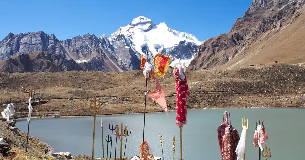
arvati Sarovar & Shiv Parvati Temple |
4,501 m |
Glacial lake at the foot of Adi Kailash. Reflects the full snow peak in still water at sunrise. The Shiva-Parvati temple on its shore is ancient and simple. Water temperature 2–6°C year-round. Sunrise darshan (5:30–7:00 AM) is the defining experience of the yatra. |
|
Gauri Kund & Adi Kailash Full Darshan |
~5,000 m |
Highest accessible water body on the circuit; bathing not permitted. From here the complete form of Adi Kailash at 5,945 metres is visible directly overhead — the moment the entire journey has been moving toward. |
Table 5 — All 18 Sightseeing Points on the Adi Kailash & Om Parvat Circuit
A few of these are worth dwelling on. Kainchi Dham, the ashram of Neem Karoli Baba at Bhowali, is visited by thousands of pilgrims who come specifically for it — Steve Jobs visited in 1974, Mark Zuckerberg in 2015, and both have spoken about its impact on them, which has given the ashram a curious contemporary significance alongside its deep spiritual one. The Malpa memorial, passed on the Dharchula–Gunji road, marks the site of the devastating 1998 landslide that killed 255 people including 60 Kailash Mansarovar pilgrims and an Indian athletics team. It's a sobering stop that puts the mountain environment in perspective in a way no guidebook quite can. And the Byans villages — Gunji, Nabi, Napalchu, Kuti — with their combined population of 968 people speaking the Byangsi language, are among the most extraordinary communities in India.
Jolingkong and Parvati Sarovar: Where the Yatra Finds Its Heart
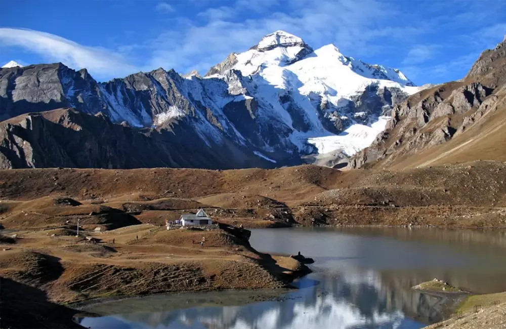
Jolingkong at 4,378 metres is the highest campsite on the standard circuit and the base from which you walk to Parvati Sarovar and Gauri Kund, and it's the place where most pilgrims describe the moment the yatra becomes something more than a journey. Adi Kailash is visible from here in its entirety — the five-tiered snow formation, the Parvati Mukut to one side, the Pandav Parvat group of five peaks to the other, and the Brahma Parvat rising behind the camp. The KMVN guesthouses here are basic, and the altitude means that even a short walk leaves you slightly breathless, but none of that matters very much once you've seen what's in front of you.
Parvati Sarovar, two to three kilometres from Jolingkong, is a glacial lake at 4,501 metres whose still surface on a clear morning reflects the full form of Adi Kailash above it. The Shiva Parvati temple on its shore is ancient and simple and tends to be full of pilgrims doing puja in the early hours. Water temperature in the lake is between 2 and 6 degrees Celsius year-round — many pilgrims take a ritual dip, which is extremely cold and memorable in a way that is difficult to convey to anyone who hasn't done it. Sunrise, between 5:30 and 7:00 AM, is the best time for darshan, when the light on Adi Kailash moves from deep blue to amber to brilliant white in the space of twenty minutes and the lake holds the whole thing perfectly. Gauri Kund, a further two kilometres beyond at around 5,000 metres, is the highest water body on the circuit; bathing is not permitted, but the view of the peak directly overhead is the defining visual of the entire yatra.
Cost, Season and the Practical Details
The yatra runs from May to October, with the formal season opening on 8 May 2026 from Jolingkong. May–June and September–October are the best windows — skies are clearest, both routes are open, and the Om Parvat ॐ formation is most distinctly visible before the monsoon changes the snowline. July and August are monsoon months: the Malpa and Budhi sections of the Dharchula–Gunji road are vulnerable to landslides, Om Parvat views are frequently obscured by cloud cover, and the whole experience becomes significantly more uncertain. It's not recommended unless you're flexible and experienced with Himalayan conditions.
Costs vary substantially depending on how you travel. The cheapest complete packages from Kathgodam — basic accommodation, shared vehicle, ILP, guide — run from ₹16,000 per person, though these are not recommended for first-time Himalayan travellers. The standard bracket, which is the most popular and the best value for most people, sits at ₹27,000 to ₹34,000 and typically includes a private vehicle, twin-sharing rooms, three meals daily and a proper guide. Premium packages with the best vehicles, solo occupancy rooms and dedicated guides go up to ₹75,000 and above. For experienced independent travellers who want to self-organise, the in-valley cost comes down to ₹12,000–₹18,000, with the UTC bus from Delhi at ₹1,130 being the most economical way to get there. The table below pulls everything together.
| What You Need to Know | Answer |
|---|---|
|
Yatra season 2026 |
Opens 8 May 2026 from Jolingkong. Closes October/early November. Best months: May–June and September–October. Avoid July–August (monsoon landslides on Dharchula-Gunji road). |
|
Total duration — standard circuit |
8 days / 7 nights from Kathgodam. 6 days if starting from Pithoragarh. Helicopter-assisted version: 2–3 days from Pithoragarh. |
|
Budget package (per person) |
₹16,000–₹22,000. Basic accommodation, shared vehicle, ILP included. Not recommended for first-time Himalayan travellers. |
|
Standard package (per person) |
₹27,000–₹34,000. Most popular bracket. Private vehicle, twin-sharing rooms, three meals daily, ILP, experienced guide. |
|
Premium package (per person) |
₹45,000–₹75,000+. Best vehicles, solo/twin rooms, dedicated guide, 2 buffer days covered for weather delays. |
|
Self-organised total cost estimate |
₹12,000–₹18,000 per person in-valley (excluding travel to Kathgodam). Requires mountain travel experience and permit process familiarity. |
|
Cheapest way to reach Dharchula |
UTC bus from Delhi Anand Vihar ISBT: ₹1,070–₹1,130. Daily departures 4:30–5:30 PM. Reaches Dharchula in 21–24 hours. |
|
Nearest railway station |
Kathgodam (~310 km from Dharchula). Well connected to Delhi, Lucknow, Kolkata on overnight trains. |
|
Nearest airport |
Pantnagar (~301 km from Dharchula). Flights from Delhi via IndiGo, Air India, SpiceJet. |
|
Mobile connectivity beyond Dharchula |
BSNL only beyond Gunji. Jio and Airtel work in Dharchula and parts of Pithoragarh. Get a BSNL SIM before you go. |
|
Trekking required in 2026? |
Minimal. BRO road opened in 2020 made the circuit fully motorable. Only 2–3 km walk at Jolingkong to Parvati Sarovar; ponies available for those who need them. |
|
Temperature range during season |
Day: 10–20°C at Gunji; 5–12°C at Jolingkong. Night: 0–5°C at Gunji; −5 to 0°C at Jolingkong. Pack thermal layers regardless of month. |
|
Total sightseeing points on full circuit |
18 — from Kainchi Dham in the Kumaon foothills to Gauri Kund below Adi Kailash. |
|
What changed after BRO road opened (2020) |
Before 2020: ~200 km full trek. After 2020: entire circuit motorable. The yatra is now accessible to senior citizens and those without prior trekking experience. |
|
Best time for Om Parvat darshan |
May to July — the ॐ snow formation is clearest before monsoon changes the snowline. Cloud cover is the main risk; plan for a buffer day at Gunji. |
|
Inner Line Permit — who needs it? |
All Indian nationals entering beyond Tawaghat. Foreign nationals need a Protected Area Permit (PAP) — verify with DM Pithoragarh well in advance. |
Table 6 — Season, Costs, Logistics & Quick Reference
The People Who Call This Valley Home
The Kuthi Valley — through which the upper part of the route passes beyond Gunji — is the territory of the Byans community, one of four Bhotiya groups of Kumaon. There are five Byans villages in the valley: Gunji, Nabi, Rongkang, Napalchu and Kuti, with a combined population of 968 people who speak Byangsi, a distinct Tibeto-Burman language. Their way of life was shaped for centuries around seasonal migration between the high summer pastures near Tibet and lower winter villages, and a trading economy that moved wool, salt and grain through Lipulekh Pass to Taklakot in Tibet — a route that closed after 1962 and only partially reopened for pilgrims in 1992. Kuti, the last village at 3,700 metres, is home to just five families year-round. It's one of the most remote permanently inhabited places in India, and the fact that it carries the name of Kunti — the Pandava mother — gives it a mythological gravity that sits comfortably alongside its geographical reality.
Before You Book
The Adi Kailash Yatra in 2026 is more accessible than it has ever been — the road infrastructure is in place, the permit process is streamlined, the season opens in May and runs through October, and you can now complete the circuit without any prior trekking experience. Yet it retains, in the upper valley and at the sacred sites, the quality that makes it worth doing in the first place: a genuine remoteness, a silence in the Kuthi Valley that no other pilgrimage circuit in Uttarakhand quite replicates, and landscapes — Parvati Sarovar at sunrise, Om Parvat's ॐ from Nabhidhang, the full form of Adi Kailash from Gauri Kund — that are simply extraordinary.
Plus, if you're a Shiv bhakt who has always wanted to do the Kailash Mansarovar Yatra but found it logistically overwhelming, this is the closest experience available within Indian territory. The mountain, the lake, the sacred geography — it's all here.
The 2026 season opens on 8 May. Registrations are open from late February. Go before the summer crowds peak, or wait for September when the post-monsoon clarity makes the Om Parvat darshan particularly sharp. Either way, go with at least one buffer day in your itinerary — the mountains will thank you for it