
Published On - Jun 09, 2026
Updated On - Jul 11, 2026
25 min
Meghalaya Travel Guide 2026: The Abode of Clouds, the Living Root Bridges and the World's Wettest Place
Shillong, Cherrapunji, Mawlynnong, Dawki and the living root bridges — what to see, when to go and what most guides don't tell you.
Located in the northeastern corner of India, sharing a long border with Bangladesh to the south and connected to the rest of the country through Assam, Meghalaya is everything you want from a Northeast India trip without the permit complications of Arunachal or the travel distances of Nagaland, yet different enough from the standard Himalayan hill station circuit to feel like a completely new country. There's plenty to do across its three distinct regions — the East Khasi Hills around Shillong and Cherrapunji, the Jaintia Hills to the east, and the Garo Hills in the west — and travellers interested in ecology, tribal culture and landscapes that exist nowhere else in India will be pleasantly surprised by what Meghalaya has in store. You can walk across a living root bridge grown over thirty years from the aerial roots of a rubber fig tree in the forests of Nongriat, watch the Nohkalikai Falls — India's tallest plunge waterfall at 340 metres — drop off the Cherrapunji plateau, and drive to Mawlynnong, awarded Asia's cleanest village in 2003 and immaculate to this day, all on a five-day trip from Delhi without a single permit required.
Meghalaya recorded 15.86 lakh domestic tourist arrivals in 2024 — a record, up 13% from the previous year and 33% above the pre-Covid figure of 12 lakh. The state government has committed ₹450 crore to new tourism projects in 2024–25, including the Umngot riverfront development at Dawki, waterfall experience trails at Sohra and a Living Root Museum. In the meantime, the standard circuit of Shillong, Cherrapunji, Mawlynnong and Dawki can be covered comfortably in five to six days from Guwahati, which is two and a half hours from Delhi by air. And to add to that, no Inner Line Permit is required for Indian nationals — you just show up with valid ID and go.
Shillong
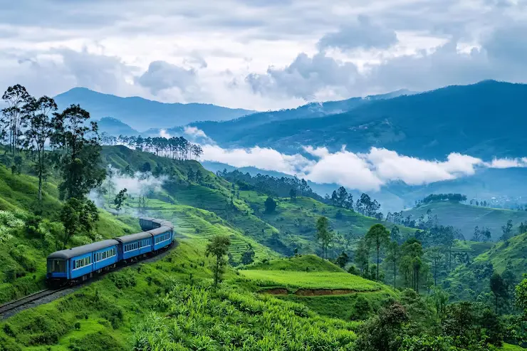
Shillong, the capital at 1,491 metres, is often called the Scotland of the East — partly for its rolling hills and colonial bungalows, and partly for a certain damp, misty quality to its mornings that is unlike most Indian hill towns. It is the right base for any Meghalaya trip and deserves at least two days rather than being treated purely as a transit stop. You can visit the Don Bosco Museum on Mawlai Nongkynmaw Road, which is the finest museum of Northeast tribal culture in India, spread across seven floors covering the art, costume, music and spiritual traditions of the region's communities, followed by Ward's Lake in the heart of the city and the Laitlum Canyon 26 kilometres out — where the hills drop into a deep canyon system with views that most people describe as the best they found anywhere in the state. The Shillong Peak viewpoint at 1,965 metres, the highest point in Meghalaya, is a half-hour drive from the centre and worth going to on a clear morning.
The café and music culture here is genuinely good and worth an evening on its own. Shillong has a deep connection with Western music going back to missionary education — the city is often called the rock music capital of India — and the Police Bazaar area has cafés, live music venues and restaurants that feel unlike any other hill town of comparable size. Dylan's Café on GS Road, named after Bob Dylan who enjoys a particular following in Meghalayan music circles, is one of the better-known spots, along with the French Café. Plus, if you want to eat proper Khasi food rather than hotel buffet fare, the dhabas around Police Bazaar serve jadoh — red rice cooked with pork, the Khasi staple — from morning and at very reasonable prices.
Cherrapunji (Sohra)
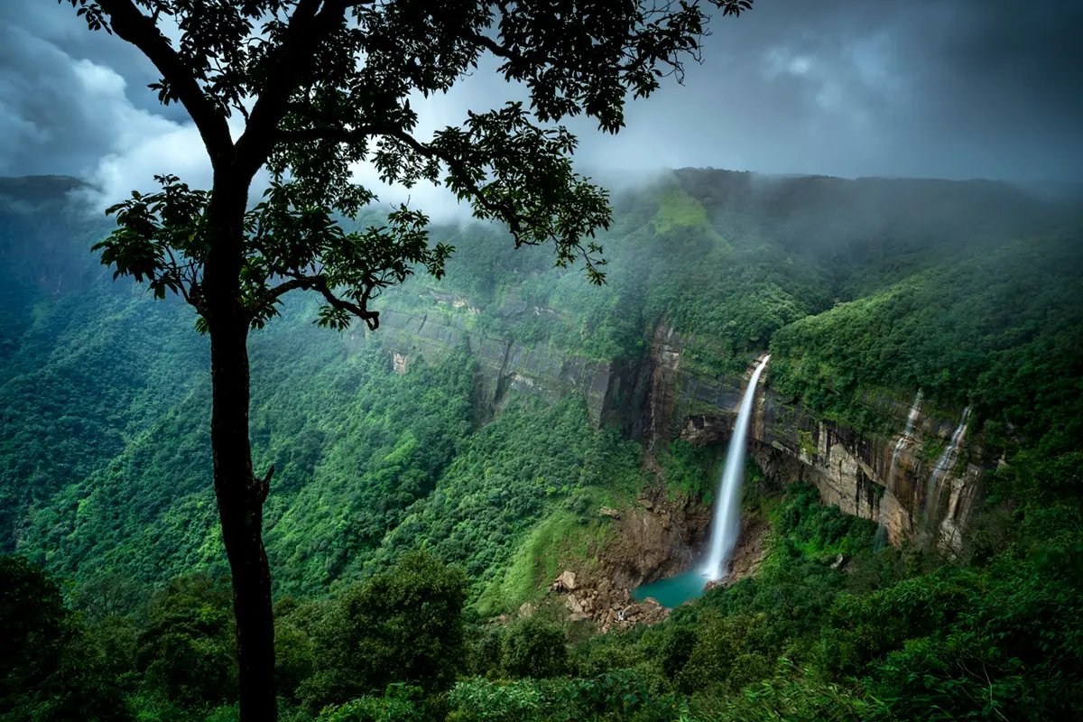
Cherrapunji, known locally as Sohra and 54 kilometres from Shillong, is where most Meghalaya trips focus, and justifiably so. It holds multiple world records for rainfall, has the Nohkalikai Falls at 340 metres (India's tallest plunge waterfall), the Seven Sisters Falls visible from a single roadside viewpoint, the Mawsmai limestone cave system, and serves as the starting point for the trek to the Nongriat double-decker living root bridge. The views from the Cherrapunji plateau across the Bangladesh plains are good on clear days, particularly in October and November. You can stay overnight in Cherrapunji rather than day-tripping from Shillong, which is the right decision — waking up on the plateau with the morning mist rolling in from the Bangladesh side and the falls audible in the distance is one of the better quiet experiences the state offers.
Nohkalikai is the centrepiece — a 340-metre plunge over a cliff edge into a turquoise pool, visible from a viewpoint ten minutes from the main road. It is most dramatic from July to September at peak monsoon flow, though the surrounding forest is heavily misted and the approach slippery in those months. October to December gives you a full-flowing waterfall with clear visibility, which is the better combination for most visitors. The Seven Sisters Falls, a broad curtain of seven separate streams falling side by side off the plateau edge, is visible from the Sohra–Mawsynram road and takes five minutes to view — an easy addition on the way to Mawsynram.
The Living Root Bridges
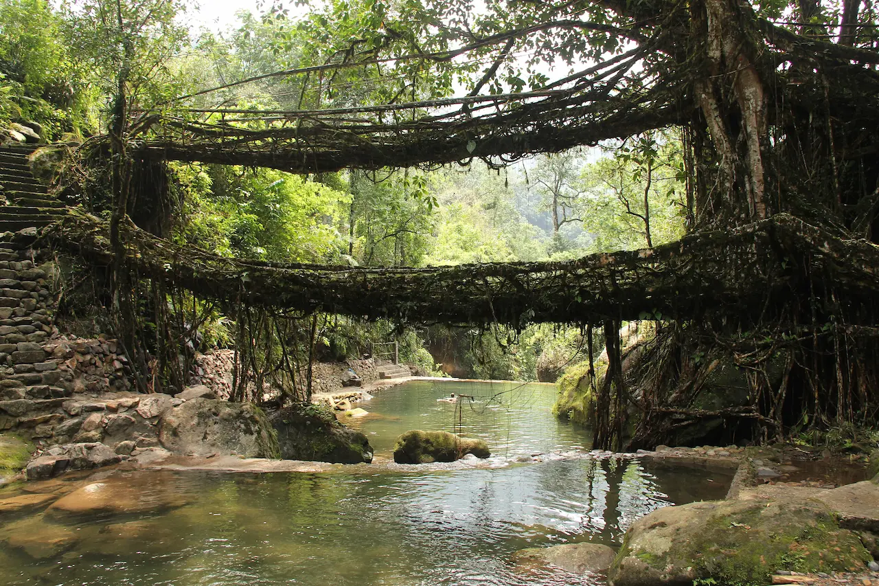
The living root bridges are the single most distinctive thing in Meghalaya and the reason most people first put the state on their list. They are grown — not built — by the War Khasi community using the aerial roots of rubber fig trees (Ficus elastica), guided across streams through hollow betel nut trunks over fifteen to thirty years until the roots form a self-supporting bridge strong enough to carry fifty or more people. Unlike any conventional bridge, they get stronger with age and are self-repairing. The oldest ones are estimated to be over five hundred years old, and there are more than seventy of them scattered across the East Khasi Hills. The double-decker root bridge at Nongriat village — two stacked levels of living roots — is the most famous and is on UNESCO's World Heritage tentative list since 2023.
You reach Nongriat by descending 3,500 stone steps from Tyrna village, about 15 kilometres from Cherrapunji on the road toward Dawki. The descent takes about 1.5 to 2 hours and the climb back up takes longer — the full round trip is 4 to 6 hours and is genuinely demanding, so good shoes, a water bottle and a local guide are all worth having. The entry fee is ₹50. The Rainbow Falls, a natural pool with crystal-clear water, is about an hour's walk beyond the bridge and worth extending for if you have the energy. The Riwai root bridge near Mawlynnong is a much gentler alternative — a 300-metre walk from the road, accessible to families and older travellers, and a good introduction to the concept even if it does not have the same drama as Nongriat.
| Bridge | Location | Difficulty | Entry Fee | What to Know |
|---|---|---|---|---|
|
Double Decker — Nongriat |
Nongriat village via Tyrna, ~15 km from Cherrapunji |
Hard — 3,500+ stone steps each way, 4–6 hrs round trip |
₹50 per adult |
Most famous. UNESCO tentative list 2023. Two stacked levels of living roots. Rainbow Falls 1 hr further. Hire a guide — trail unmarked in places. |
|
Riwai Root Bridge |
Riwai village, next to Mawlynnong |
Very easy — 300m flat walk |
₹50 per adult |
Most accessible. Good for families. Often crowded 10 AM–3 PM; go early. |
|
Mawlynnong Village Bridge |
Inside Mawlynnong village |
Very easy — village path |
Included in village entry |
Single-decker. Right inside the cleanest village. Convenient with the Mawlynnong visit. |
|
Nongbareh Bridge |
East Jaintia Hills, ~104 km from Shillong |
Moderate — 1 hr forest trail |
~₹50 |
Rarely visited. Quieter than Nongriat. Good for those who want fewer crowds. |
Table 1 — Living Root Bridges: Which One and How to Get There
Mawlynnong
Mawlynnong, 90 kilometres from Shillong near the Bangladesh border, was awarded Asia's cleanest village by Discover India magazine in 2003 and has kept that standard with visible community effort — bamboo dustbins along every path, swept grounds from early morning, and the kind of civic discipline that most Indian towns would benefit from studying. The village takes about thirty minutes to walk around, and the sky walk above the forest canopy offers views across to Bangladesh on a clear day. It gets crowded between 10 AM and 3 PM on weekends, so arriving before 9 AM or after 4 PM gives you the place in a more natural state. A few good homestays operate in and around the village for those who want to stay overnight rather than treating it as a day trip. The single-decker Riwai root bridge is two kilometres away and easily combined with the visit.
Dawki and the Umngot River
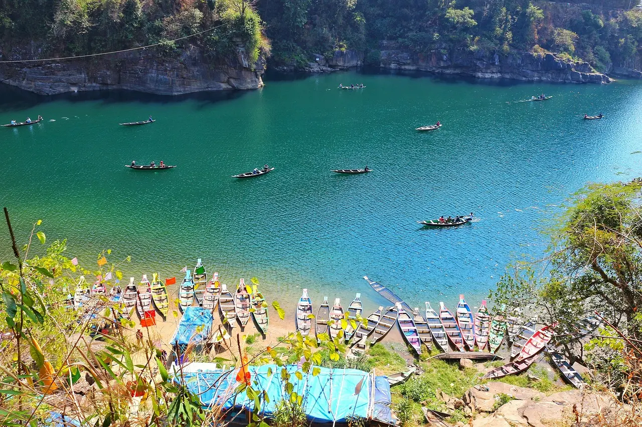
Dawki, 82 kilometres from Shillong on the Bangladesh border, is where the Umngot River is clear enough that boats appear to float suspended in mid-air — the photograph has been shared so widely that the place has become crowded in peak season, but the reality is still good enough to justify the drive. The clarity is best from November to February, and going before 9 AM means you get the river with fewer boats on it and a calmer surface. Boating costs ₹300 to ₹600 per boat for thirty to forty-five minutes. The state government's ₹450 crore tourism investment in 2024–25 includes an Umngot riverfront development at Dawki, which will eventually add more structure here. Shnongpdeng, six kilometres away on the same river, is quieter and has camping and kayaking — worth knowing if you want the river experience with more flexibility and fewer day-trip crowds.
Mawsynram: The World Record No One Visits
Mawsynram, 65 kilometres from Shillong, holds the world record for average annual rainfall — approximately 12,000 millimetres a year, or about twelve metres of rain. It is visited by very few tourists, partly because it rains heavily for most of the year and partly because it is not on the standard circuit. It is worth a half-day detour for those who are curious about what the world's wettest place actually looks like and feels like — the vegetation is extraordinary, the landscape shaped entirely by water, and the sense of the place is quite different from anywhere else in Meghalaya. The Rain and Bamboo Interpretation Centre, announced as part of the 2024–25 tourism investment, will eventually give the village a dedicated visitor attraction.
When to Go
| Month | Weather (Shillong) | Waterfalls | Dawki River | Best For |
|---|---|---|---|---|
|
Oct |
15–22°C. Post-monsoon clear. |
Very full — best combination of volume and visibility |
Excellent |
Best single month. Clear skies, full waterfalls, comfortable. First pick for any trip. |
|
Nov–Dec |
10–18°C. Clear and cool. |
Good flow |
Best clarity of the year |
Dawki at its most transparent. Christmas crowd in Shillong. Good for photography. |
|
Jan–Feb |
8–15°C. Cold and dry. |
Low to moderate |
Best of the year |
Clearest river. Cold but manageable. Nongriat trek comfortable. Fewest tourists. |
|
Mar–Apr |
15–24°C. Warming up. |
Low flow |
Good |
Spring flowers. Pleasant temperatures. Fewer tourists than Oct–Dec. Good for root bridge treks. |
|
May |
20–28°C. Pre-monsoon warm. |
At minimum |
Acceptable |
Last comfortable month. Book early — tourists arrive before monsoon closes routes. |
|
Jun–Sep |
18–28°C. Heavy monsoon. |
Spectacular — Nohkalikai at peak |
Poor — silted |
Waterfalls most dramatic but trails are slippery and sometimes impassable. Not for first-timers. |
Table 2 — Month-by-Month Season Guide
Getting There
| Route | Details | Journey Time | Best For |
|---|---|---|---|
|
Fly Guwahati → road to Shillong |
Delhi → Guwahati (2.5 hrs on IndiGo, Air India, SpiceJet, Vistara) → Shillong by shared taxi or private cab (103 km, 2.5–3 hrs) |
5–6 hrs total |
Most popular and most practical. Best flight-to-destination option. |
|
Fly to Umroi Airport, Shillong |
Shillong's own airport, 30 km from city. Limited schedule mainly from Kolkata. |
Varies — check current schedule |
Convenient if available. Always confirm frequency before planning around it. |
|
Train to Guwahati → road |
Overnight Rajdhani Express Delhi–Guwahati (~18 hrs) → road to Shillong (2.5–3 hrs) |
21–22 hrs total |
Budget travellers. Rajdhani is comfortable; good option if you prefer trains. |
|
Road from Guwahati (NE circuit) |
If already in Assam, Shillong is 103 km on NH6 — well-maintained highway. |
2.5–3 hrs |
Travellers combining Assam + Meghalaya on one trip. |
Table 3 — How to Reach Meghalaya
What to Eat
Meghalayan cuisine is shaped by the Khasi, Jaintia and Garo communities and is quite different from the rest of the Northeast and from most Indian cuisines that visitors will have encountered. Jadoh (red rice with pork) is the essential starting point, available at dhabas around Police Bazaar in Shillong from morning. Dohneiiong — pork with black sesame seeds — is equally good and more distinctive. Tungrymbai, a fermented soybean preparation, is worth trying at a homestay where it is prepared fresh rather than at a tourist-facing restaurant. And if you're staying with a Khasi family and are offered kwai — betel nut with betel leaf and lime, the traditional gesture of hospitality — accepting it (whether or not you actually chew it) is the right response.
| Dish | What It Is and Where to Try It |
|---|---|
|
Jadoh |
Red rice cooked with pork or chicken — the Khasi staple. Available at most local dhabas in Shillong, particularly around Police Bazaar. The most important dish to try in the state. |
|
Dohneiiong |
Pork cooked with black sesame seeds — rich, slightly nutty, very distinctive. Served with rice at Khasi restaurants throughout Shillong and Cherrapunji. |
|
Tungrymbai |
Fermented soybean preparation — strong-flavoured, eaten as a side with rice. An acquired taste for most visitors but worth trying at a homestay where it is prepared fresh. |
|
Shillong cafés |
Shillong has a café culture unlike any Indian hill town of its size — places like Dylan's Café (named after Bob Dylan, enormously popular in Meghalayan music culture) and the French Café on GS Road are worth an evening. The city's colonial heritage and Christian community have created a food and music culture that is distinctly its own. |
Table 4 — What to Eat in Meghalaya
What It Costs
| Budget Level | 5-Day Cost (2 people) | What You Get |
|---|---|---|
|
Budget |
₹12,000–₹20,000 total |
Homestays ₹800–1,500/night, local dhabas and Khasi food, shared sumos between destinations. Meghalaya has some of the best budget homestays in the Northeast. |
|
Mid-range |
₹25,000–₹45,000 total |
3-star hotels or boutique guesthouses ₹2,500–5,000/night, private cab (₹2,500–3,500/day), restaurants in Shillong. |
|
Premium |
₹55,000–₹90,000 total |
Boutique resorts like Ri Kynmaw or Cherrapunji Holiday Resort ₹6,000–12,000/night, private vehicle throughout. |
|
Standard package (5N/6D from Guwahati) |
₹18,000–₹32,000 per person |
Ground package including accommodation, private vehicle, most meals. Flight to Guwahati extra. |
|
Nongriat trek (add-on cost) |
₹500–₹1,500 per person |
Guide (recommended) + entry fees + transport to Tyrna. Do not go without a guide first time. |
Table 5 — Budget Guide (2026)
All the Key Destinations
| Destination | Distance from Shillong | Best Season | Time Needed | Best For |
|---|---|---|---|---|
|
Shillong |
Base city |
Oct–Jun |
2 nights minimum |
Don Bosco Museum, Laitlum Canyon, Umiam Lake, Police Bazaar food, café culture |
|
Cherrapunji (Sohra) |
54 km / 1.5–2 hrs |
Oct–May |
1–2 nights |
Nohkalikai Falls (340m), Seven Sisters Falls, Mawsmai Cave, starting point for Nongriat trek |
|
Nongriat — double-decker bridge |
~70 km from Shillong via Tyrna |
Oct–May |
Full day — start by 7 AM |
The most famous living root bridge. 3,500 stone steps down and back up. 4–6 hours round trip. |
|
Mawlynnong |
90 km / 2.5 hrs |
Oct–May |
Half day to 1 full day |
Asia's cleanest village (awarded 2003, maintained since). Riwai bridge nearby. Bangladesh views. |
|
Dawki — Umngot River |
82 km / 2.5 hrs |
Nov–Feb (clearest) |
Half day |
Crystal-clear river. Boats appear to float in air. Go before 9 AM to beat crowds. ₹300–600 per boat. |
|
Mawsynram |
65 km / 2 hrs |
Year-round |
Half day |
World's wettest place — ~12,000 mm avg annual rainfall. Off the main circuit; worth it for the curious. |
|
Laitlum Canyon |
26 km / 45 min |
Oct–Jun |
2–3 hours |
Best viewpoint near Shillong. Rolling hills, deep canyon. Go at sunrise. |
|
Mawphlang Sacred Forest |
25 km / 45 min |
Oct–Jun |
2–3 hours |
Ancient community-protected forest. No tree or plant may be removed — enforced for centuries. |
|
Garo Hills — Tura / Balpakram |
~350 km / 7–8 hrs |
Oct–Apr |
2 days minimum |
Nokrek Biosphere Reserve (UNESCO), Baro tribal culture, almost no tourists. For those with 10+ days. |
Table 6 — Destinations at a Glance
Quick Reference
| What You Need to Know | The Answer |
|---|---|
|
State capital |
Shillong — 1,491m, population ~400,000. Base for all Meghalaya circuits. |
|
State size |
22,429 sq km. Formed 21 January 1972 from Assam districts. |
|
Three major tribal communities |
Khasi (East and West Khasi Hills), Jaintia (Jaintia Hills), Garo (Garo Hills) — each with distinct language, tradition and culture. |
|
Languages |
Official: English, Khasi, Garo. English spoken and understood across the state. |
|
Domestic tourist arrivals 2024 |
15.86 lakh — record figure, up 13% from 14.03 lakh in 2023. 33% above pre-Covid baseline of 12 lakh. |
|
World's wettest place |
Mawsynram, East Khasi Hills — ~12,000 mm average annual rainfall. Cherrapunji holds single-month and single-year records. |
|
Nohkalikai Falls |
340 metres — India's tallest plunge waterfall. Near Cherrapunji. Best October–December. |
|
Living root bridges — UNESCO status |
World Heritage tentative list since 2023. Grown from rubber fig tree roots over 15–30 years. Nongriat double-decker most famous. |
|
ILP required? |
No — Indian nationals need no permit for Meghalaya. Just carry valid ID. |
|
Umngot River (Dawki) — best months |
November to February. Water clearest in this window. Crowded in season — go early morning. |
|
Nearest major airport |
Guwahati — 103 km from Shillong, 2.5–3 hrs by road. Direct flights from Delhi (2.5 hrs). |
|
Shillong's own airport |
Umroi Airport, 30 km from city. Limited connections mainly Kolkata. Check schedule. |
|
Tourism investment 2024–25 |
₹450 crore — Umngot riverfront at Dawki, waterfall trails at Sohra, Living Root Museum at Wahlyngkhat among projects. |
|
Best first circuit (no ILP, easy) |
Shillong 2N → Cherrapunji 1–2N → Mawlynnong + Dawki day trip. 5–6 days total from Guwahati. |
|
Nongriat trek — honest assessment |
3,500+ stone steps each way. 4–6 hours round trip. Genuinely hard. Good shoes, water, snacks and a guide essential. Worth every step. |
|
Best single month to visit |
October — post-monsoon clarity, full waterfalls, comfortable temperatures, all routes open. |
Table 7 — Meghalaya Master Reference 2026
Before You Book
Meghalaya is the right starting point for a first Northeast trip — no permit required, easy access from Guwahati, clear standard circuit, and experiences that don't exist anywhere else in India. Five to six days covers Shillong, Cherrapunji, Mawlynnong and Dawki comfortably. October is the best single month. Three days is possible but rushed and you will come back wishing you had booked more.
The one mistake most visitors make is treating Cherrapunji as a day trip from Shillong. A night on the plateau — waking up with the morning mist rolling in and the falls audible from the guesthouse — is a different experience from arriving at 10 AM and leaving by 5 PM, and it is the kind of thing people mention when they talk about the trip afterwards. Book the Nongriat trek for an early morning start — 7 AM from Tyrna at the latest — and you will be back by early afternoon with the rest of the day free for the waterfall viewpoints. And if you go only to Mawlynnong and skip Dawki, go early. The village at 8 AM is worth considerably more than the village at noon.
The living root bridges have been growing for five centuries without any human engineering beyond the initial guidance of a few roots. The place that grows them is also the wettest place on earth. Meghalaya is worth more than a weekend, and most people who go once come back to see the parts they missed.